Excavator GPS Machine Control Basics for Efficient Excavation Projects
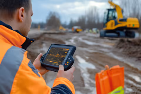
Excavator GPS Machine Control is an advanced construction technology that combines satellite positioning, digital site models, sensors, and onboard computers to guide excavation work with high accuracy. The system helps machine operators perform digging, grading, trenching, and earthmoving tasks according to design specifications displayed directly inside the excavator cabin.
Traditional excavation often depends on manual measurements, stakes, and repeated surveying. GPS machine control reduces this dependency by providing real-time positioning data and visual guidance. As a result, operators can work more efficiently while maintaining consistent accuracy across construction projects.
The technology has become increasingly important in infrastructure development, highway construction, mining operations, utility installation, and large-scale earthmoving projects.
How Excavator GPS Machine Control Works
The system continuously determines the excavator's position and compares it with a digital construction model.
The process generally includes:
- Receiving positioning data from GPS and GNSS satellites
- Collecting movement information from sensors mounted on the boom, arm, and bucket
- Processing data through an onboard computer
- Comparing actual excavation depth and location with project designs
- Displaying guidance information on an in-cab monitor
- Providing real-time feedback to the operator
The operator can view the exact bucket location, target depth, slope requirements, and excavation boundaries without leaving the cabin.
This digital workflow minimizes guesswork and improves consistency throughout the project.
Main Components of an Excavator GPS Machine Control System
| Component | Function |
|---|---|
| GNSS Receiver | Receives positioning signals from satellites |
| Antennas | Improve location accuracy and signal reception |
| Position Sensors | Monitor boom, arm, bucket, and machine movement |
| Onboard Computer | Processes positioning and design data |
| Display Monitor | Shows excavation guidance and project information |
| Communication Module | Transfers project data between office and field |
| Software Platform | Manages digital site models and machine guidance |
| Base Station or Network Corrections | Enhances positioning precision |
These components work together to create a highly accurate machine guidance environment.
Why Excavator GPS Machine Control Is Important
Construction projects require precision, efficiency, and consistent quality. Small excavation errors can result in delays, material waste, and additional corrective work.
GPS machine control addresses these challenges by helping operators:
- Achieve accurate excavation depths
- Reduce rework requirements
- Improve project productivity
- Enhance project documentation
- Optimize equipment utilization
- Improve safety by reducing ground checks
- Support digital construction workflows
As projects become more complex, machine control systems help organizations maintain quality standards while improving operational efficiency.
Common Types of Excavator GPS Machine Control Systems
Modern excavator guidance systems are available in different configurations depending on project requirements.
Indicate Systems
- Provide visual guidance to operators
- Show target and actual positions
- Require manual machine control
- Common in smaller projects
2D Machine Control
- Uses predefined elevations and slopes
- Suitable for straightforward excavation work
- Often used for trenching and utility projects
3D Machine Control
- Uses digital terrain models
- Supports complex site designs
- Enables precise grading and excavation
- Widely used in infrastructure projects
Semi-Automatic Systems
- Assist operators during excavation
- Automatically limit over-digging
- Improve consistency and productivity
Fully Integrated Intelligent Systems
- Combine automation, telematics, and machine guidance
- Support advanced digital construction environments
- Enable continuous project monitoring
Real-World Applications
Excavator GPS machine control is used across many industries.
Road and Highway Construction
- Slope creation
- Drainage channel excavation
- Foundation preparation
- Embankment shaping
Utility Installation
- Pipeline trenching
- Cable installation corridors
- Water infrastructure development
Mining Operations
- Pit development
- Material extraction guidance
- Stockpile management
Residential and Commercial Development
- Site preparation
- Foundation excavation
- Landscaping projects
Environmental Projects
- Wetland restoration
- Flood control systems
- Erosion management
The technology supports projects requiring precise earthmoving and accurate terrain modification.
Problems Solved by GPS Machine Control
Traditional excavation methods can create several operational challenges.
Common issues include:
- Over-excavation
- Under-excavation
- Frequent surveying interruptions
- Material waste
- Productivity losses
- Inconsistent excavation quality
- Extended project timelines
GPS machine control helps reduce these issues through continuous position monitoring and digital guidance.
The result is improved accuracy and more predictable project outcomes.
Key Features of Modern Systems
Current machine control platforms include numerous advanced capabilities.
Advanced Positioning
- Multi-constellation GNSS support
- Real-time correction services
- Centimeter-level accuracy
Digital Design Integration
- Importing 3D site models
- Automatic design updates
- Cloud-based project synchronization
In-Cab Visualization
- Real-time excavation guidance
- Cut-and-fill calculations
- Terrain mapping displays
Connectivity Features
- Wireless data transfer
- Remote project monitoring
- Fleet management integration
Reporting Functions
- Productivity tracking
- Equipment performance analysis
- Progress monitoring
These features help construction organizations make data-driven decisions throughout project execution.
Recent Trends and Developments
The past year has seen significant advancements in construction technology and machine automation.
Artificial Intelligence Integration (2025–2026)
- AI-powered software is increasingly being incorporated into machine control platforms.
- These systems assist with terrain analysis, workflow optimization, and predictive project planning.
- Manufacturers have improved compatibility with multiple satellite networks, increasing positioning reliability in challenging environments.
- Digital construction platforms now enable real-time synchronization between field equipment and project management teams, improving collaboration and data accessibility.
- Semi-autonomous excavation functions continue to expand, helping operators maintain target grades and excavation limits more efficiently.
- Construction companies increasingly combine machine control data with telematics systems for comprehensive fleet monitoring and operational analysis.
- These developments support the broader movement toward connected construction sites and intelligent equipment ecosystems.
Regulations and Industry Standards
Excavator GPS machine control systems are often used within regulatory and engineering frameworks.
Relevant considerations may include:
- Occupational safety requirements
- Surveying and geospatial standards
- Construction quality specifications
- Infrastructure project guidelines
- Environmental compliance requirements
- Equipment safety regulations
Specific requirements vary by country and project type. Project managers typically ensure machine control workflows align with applicable engineering standards and local regulations.
Useful Tools and Platforms
Several technology providers develop machine control and construction positioning solutions.
Common Industry Platforms
- Topcon machine control systems
- Leica Geosystems machine guidance solutions
- Trimble Earthworks platforms
- Hexagon construction technology solutions
- Caterpillar Grade technologies
- Komatsu Intelligent Machine Control
Learning Resources
- Construction technology training programs
- GNSS positioning courses
- Digital construction certifications
- Equipment manufacturer documentation
- Civil engineering technology resources
- Surveying and geospatial education materials
These resources help operators and project managers understand machine guidance technologies and best practices.
Benefits for Construction Projects
Organizations adopting excavator GPS machine control often experience measurable operational improvements.
Potential benefits include:
- Greater excavation accuracy
- Reduced material movement
- Lower rework requirements
- Faster project completion
- Improved operator confidence
- Better project documentation
- Enhanced resource planning
- Stronger quality control processes
The technology contributes to more efficient and predictable construction workflows.
FAQs
What is excavator GPS machine control?
Excavator GPS machine control is a technology that combines satellite positioning, sensors, and digital construction models to guide excavation equipment with high accuracy during earthmoving operations.
How accurate are GPS machine control systems?
Modern systems can achieve centimeter-level accuracy when using GNSS correction technologies, base stations, or network correction services.
Is GPS machine control only used for large projects?
No. While commonly used on major infrastructure projects, the technology can also support residential developments, utility installation projects, and smaller earthmoving operations.
What is the difference between 2D and 3D machine control?
2D systems primarily use elevation and slope information, while 3D systems utilize complete digital terrain models and project designs for more advanced guidance.
Does GPS machine control replace surveyors?
No. Surveyors remain essential for project planning, control point establishment, verification, and quality assurance. Machine control technology complements surveying activities rather than replacing them.
Conclusion
Excavator GPS Machine Control has become an important component of modern construction and earthmoving operations. By combining GNSS positioning, digital design models, sensors, and intelligent software, the technology enables highly accurate excavation and grading activities. It helps reduce rework, improve productivity, enhance project quality, and support data-driven decision-making.
As construction technology continues to evolve through artificial intelligence, cloud connectivity, automation, and advanced telematics, GPS machine control systems are expected to play an increasingly significant role in infrastructure development, mining, utility installation, and commercial construction projects. Organizations adopting these technologies can benefit from improved operational efficiency while supporting the ongoing transition toward digital construction practices.