Jump to a Chapter

Seismometers Explained: Earthquake Detection Technology, Working Principles, and Seismic Monitoring Insights

Seismometers Explained: Earthquake Detection Technology, Working Principles, and Seismic Monitoring Insights

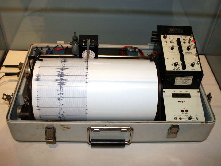
Seismometers are highly sensitive scientific instruments designed to detect, measure, and record vibrations of the Earth. They play a vital role in monitoring earthquakes, volcanic activity, tectonic movements, and other sources of ground motion. Used by geological surveys, research institutions, universities, and seismic monitoring agencies, seismometers contribute to understanding Earth's dynamic processes and improving earthquake monitoring capabilities.


Modern seismometers combine precision mechanical sensors, digital electronics, satellite communication, GPS synchronization, and advanced data processing software. With the integration of artificial intelligence (AI), cloud computing, and real-time monitoring networks, seismic observation has become more accurate and responsive than ever before.

This guide explores seismometer technology, working principles, instrument components, seismic monitoring systems, and emerging innovations from an educational perspective. It does not provide engineering, disaster management, emergency response, legal, regulatory, or professional geophysical advice.

What Is a Seismometer?

A seismometer is a scientific instrument that measures ground motion caused by natural or human-made vibrations.

These instruments are commonly used by:

  • Geological survey organizations
  • Earthquake monitoring centers
  • Universities
  • Research laboratories
  • Volcanic observatories
  • Engineering and infrastructure monitoring agencies

The recorded information helps scientists study seismic activity and Earth's internal structure.

What Does a Seismometer Measure?

A seismometer detects extremely small movements of the ground.

These movements may result from:

  • Earthquakes
  • Volcanic activity
  • Landslides
  • Ocean waves
  • Construction activity
  • Controlled explosions
  • Tectonic plate movement

The instrument records these vibrations as seismic data for analysis.

Basic Working Principle

A seismometer operates by detecting the relative motion between the Earth and a suspended reference mass.

The general process includes:

  • Ground movement occurs.
  • The instrument housing moves with the Earth.
  • An internal mass resists movement due to inertia.
  • Relative motion is measured by sensors.
  • Electrical signals are generated.
  • Digital systems record and process the data.

This principle allows even very small ground vibrations to be detected.

Main Components of a Seismometer

Modern seismometers include several precision-engineered components.

Major components may include:

  • Sensor assembly
  • Suspended inertial mass
  • Spring or suspension mechanism
  • Electromagnetic sensor
  • Signal amplifier
  • Analog-to-digital converter
  • Data logger
  • Power supply
  • GPS timing module
  • Communication system

Each component contributes to accurate seismic measurements.

Inertial Mass System

The inertial mass is the core sensing element.

Its purpose is to:

  • Remain relatively stationary during ground motion
  • Provide a reference point
  • Enable precise motion measurement

The movement between the mass and the instrument frame is converted into measurable signals.

Sensor Technologies

Modern seismometers use different sensing technologies.

Common types include:

Electromagnetic Sensors

Use magnetic induction to detect relative motion.

Force-Balance Sensors

Apply electronic feedback to maintain the sensor in a balanced position while measuring motion with high precision.

Capacitive Sensors

Measure displacement using changes in electrical capacitance.

The choice of sensor depends on the instrument's intended application.

Types of Seismometers

Different types of seismometers are designed for different monitoring needs.

Short-Period Seismometers

Optimized for detecting high-frequency seismic waves from nearby earthquakes.

Broadband Seismometers

Capable of recording a wide range of seismic frequencies, making them suitable for regional and global monitoring.

Strong Motion Accelerometers

Designed to measure intense ground shaking during large earthquakes, especially for engineering and structural analysis.

Ocean-Bottom Seismometers

Installed on the seafloor to monitor seismic activity beneath oceans and offshore fault zones.

Digital Data Acquisition

Modern instruments convert analog signals into digital information.

Digital systems may perform:

  • Signal sampling
  • Noise reduction
  • Time synchronization
  • Data storage
  • Event detection

Digital processing improves data quality and enables remote analysis.

GPS Time Synchronization

Accurate timing is essential for seismic monitoring.

GPS technology helps:

  • Synchronize monitoring stations
  • Timestamp seismic events
  • Compare recordings from multiple locations
  • Improve earthquake location accuracy

Precise timing supports coordinated global seismic observations.

Seismic Monitoring Networks

Individual seismometers are often connected through monitoring networks.

These networks may include:

  • National seismic stations
  • Regional monitoring systems
  • Global observation networks
  • Volcanic monitoring stations
  • Tsunami monitoring systems

Networked observations improve the detection and analysis of seismic events.

Earthquake Detection

Seismometers are central to earthquake monitoring.

Recorded information helps scientists determine:

  • Earthquake location
  • Magnitude
  • Depth
  • Origin time
  • Wave propagation

Official earthquake information is typically issued by authorized geological or government agencies.

Seismic Waves

Earthquakes generate several types of seismic waves.

Major wave categories include:

Primary (P) Waves

The fastest seismic waves, capable of traveling through solids, liquids, and gases.

Secondary (S) Waves

Travel more slowly than P waves and move only through solid materials.

Surface Waves

Travel along Earth's surface and are often associated with stronger ground shaking during large earthquakes.

Studying these waves helps scientists understand Earth's structure and earthquake characteristics.

Volcanic Monitoring

Seismometers are also used to observe volcanic activity.

Applications include:

  • Monitoring magma movement
  • Detecting volcanic tremors
  • Supporting eruption research
  • Tracking seismic changes near volcanoes

Seismic data is one of many tools used in volcanic monitoring.

Structural and Engineering Applications

Beyond natural hazards, seismometers may support:

  • Bridge monitoring
  • Dam monitoring
  • Tunnel projects
  • High-rise building studies
  • Infrastructure research

Engineering applications depend on project requirements.

Artificial Intelligence in Seismic Monitoring

AI technologies are increasingly used in geophysical research.

Potential applications include:

  • Automated earthquake detection
  • Signal classification
  • Noise filtering
  • Pattern recognition
  • Predictive equipment maintenance

AI supports researchers by improving data analysis and operational efficiency.

Remote Monitoring

Many modern seismometers transmit information automatically.

Communication technologies may include:

  • Satellite links
  • Cellular networks
  • Internet connectivity
  • Radio communication

Remote monitoring enables continuous observation from distant locations.

Factors Influencing Instrument Performance

Several factors affect seismometer performance.

These include:

  • Sensor sensitivity
  • Frequency response
  • Installation environment
  • Ground conditions
  • Electronic noise
  • Calibration quality

Performance specifications vary according to instrument design and intended use.

Seismometer Technology Trends in 2026

Several developments continue shaping seismic monitoring.

Current trends include:

  • AI-assisted seismic analysis
  • Cloud-based monitoring platforms
  • Real-time earthquake detection
  • Smart seismic sensor networks
  • Low-power remote stations
  • Improved broadband sensors
  • Satellite-integrated communication
  • Advanced geophysical data visualization

These innovations continue improving global earthquake monitoring and geoscience research.

Frequently Asked Questions

What is a seismometer?

A seismometer is a scientific instrument that detects and records ground vibrations caused by earthquakes, volcanic activity, and other sources of seismic motion.

How does a seismometer work?

It measures the relative movement between the Earth and a suspended inertial mass, converting that motion into electrical signals for recording and analysis.

What is the difference between a seismometer and a seismograph?

A seismometer is the sensing instrument that detects ground motion, while a seismograph traditionally refers to the complete recording system, including the sensor and recording mechanism. In modern usage, the terms are often used interchangeably.

Can seismometers predict earthquakes?

No. Current scientific understanding does not support the reliable prediction of earthquakes using seismometers. These instruments detect and record seismic activity after or during its occurrence and contribute to ongoing research and monitoring.

Why is GPS important in seismic monitoring?

GPS provides highly accurate timing, allowing multiple monitoring stations to synchronize their observations and improve the precision of earthquake analysis.

Conclusion

Seismometers are among the most important instruments in Earth science, providing precise measurements of ground motion that support earthquake monitoring, volcanic research, engineering studies, and geophysical investigations. Through advances in digital electronics, broadband sensors, AI-assisted analysis, GPS synchronization, and global monitoring networks, modern seismic technology continues to enhance our understanding of Earth's dynamic processes.

As research and technology progress, seismometers are expected to become even more sensitive, connected, and capable of supporting real-time monitoring, scientific discovery, and improved understanding of seismic events.

Disclaimer

This article is intended solely for informational and educational purposes. It does not provide engineering, disaster preparedness, emergency response, legal, regulatory, or professional geophysical advice. It does not endorse, recommend, compare, rank, review, market, or promote any manufacturer, research institution, monitoring agency, software platform, or seismic equipment. Instrument specifications, monitoring methods, seismic interpretations, and operational procedures vary by organization, region, and scientific application. Readers should rely on official geological surveys and authorized emergency management agencies for earthquake alerts, public safety guidance, and hazard information.

author-image

Ravi Shankar Maurya

We create purposeful content that speaks, resonates, and drives action.

July 06, 2026 . 10 min read