LiDAR Spatial Sensors Insights for Accurate Spatial Data Collection
LiDAR spatial sensors are advanced sensing devices that use laser light to measure distances and create highly accurate three-dimensional representations of physical environments. The term LiDAR stands for Light Detection and Ranging. These sensors emit laser pulses and analyze the reflected signals to determine the location, shape, and distance of surrounding objects.
LiDAR spatial sensors have become an important technology in industries that require precise environmental awareness, mapping, navigation, and measurement. They are widely used in autonomous systems, infrastructure planning, industrial automation, environmental monitoring, and digital twin development.
Their ability to generate detailed spatial information makes them valuable in situations where traditional cameras or radar systems may have limitations.
Understanding How LiDAR Spatial Sensors Work
LiDAR spatial sensors operate by transmitting thousands or even millions of laser pulses every second. These pulses travel through the environment and reflect back after hitting objects.
The sensor calculates the time required for each pulse to return. Using the speed of light and advanced processing algorithms, the system determines the exact distance to each object.
The collected measurements are combined to create a point cloud, which is a digital representation of the surrounding environment.
Key Steps
- Laser pulse emission
- Reflection from objects and surfaces
- Time-of-flight measurement
- Distance calculation
- Point cloud generation
- Spatial data processing and visualization
This process allows LiDAR systems to produce highly detailed 3D maps with impressive accuracy.
Major Components of LiDAR Spatial Sensors
A LiDAR spatial sensing system consists of multiple integrated components working together.
Core Components
- Laser transmitter
- Optical scanning mechanism
- Receiver and photodetector
- Timing electronics
- Signal processing unit
- Positioning system
- Data processing software
Each component contributes to the accuracy, reliability, and performance of the sensing system.
Types of LiDAR Spatial Sensors
Different LiDAR technologies are designed for specific environments and operational requirements.
| Type | Description | Common Applications |
|---|---|---|
| Airborne LiDAR | Mounted on aircraft or drones | Topographic mapping, forestry |
| Terrestrial LiDAR | Installed on ground-based platforms | Construction, surveying |
| Mobile LiDAR | Mounted on moving vehicles | Road mapping, transportation |
| Solid-State LiDAR | Uses fewer moving parts | Autonomous systems |
| Flash LiDAR | Captures entire scenes simultaneously | Robotics, machine vision |
| Bathymetric LiDAR | Measures underwater terrain | Coastal studies, water mapping |
Each type offers advantages depending on operational objectives and environmental conditions.
Importance of LiDAR Spatial Sensors
Accurate spatial awareness is essential in many modern industries. LiDAR technology provides detailed environmental information that supports informed decision-making.
Benefits
- High-precision distance measurement
- Accurate 3D environmental modeling
- Rapid data collection
- Reliable operation in various lighting conditions
- Improved automation capabilities
- Enhanced safety monitoring
- Better infrastructure planning
These advantages have contributed to the growing adoption of LiDAR systems worldwide.
Applications Across Industries
LiDAR spatial sensors support a wide range of real-world applications.
Autonomous Transportation
Autonomous vehicles use LiDAR to detect obstacles, road boundaries, pedestrians, and surrounding traffic. The technology helps improve environmental awareness and navigation accuracy.
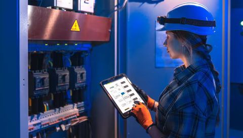
Industrial Automation
Manufacturing facilities use LiDAR-based spatial sensing for:
- Automated material handling
- Collision avoidance
- Robotic navigation
- Warehouse optimization
Smart Cities
Urban planners use LiDAR-generated data for:
- Infrastructure assessment
- Traffic planning
- Utility management
- Urban development projects
Construction and Engineering
LiDAR assists engineers in creating accurate site models before, during, and after construction projects.
Applications include:
- Building information modeling
- Progress monitoring
- Structural inspections
- Site surveying
Environmental Monitoring
Environmental organizations use LiDAR to study:
- Forest canopies
- Vegetation health
- Wildlife habitats
- Land-use changes
Agriculture
Modern agricultural operations utilize LiDAR for:
- Terrain analysis
- Precision farming
- Crop monitoring
- Irrigation planning
Energy and Utilities
LiDAR supports infrastructure management for:
- Transmission lines
- Renewable energy projects
- Pipeline inspection
- Facility monitoring
Problems Solved by LiDAR Spatial Sensors
Many industries face challenges involving measurement accuracy, visibility, and environmental complexity.
LiDAR technology helps address these challenges by providing reliable spatial information.
Common Challenges Addressed
- Inaccurate terrain measurements
- Limited visibility in complex environments
- Manual surveying inefficiencies
- Navigation uncertainties
- Infrastructure inspection difficulties
- Object detection limitations
By generating precise 3D data, LiDAR systems improve operational efficiency and situational awareness.
Key Features of Modern LiDAR Systems
Recent technological advancements have significantly enhanced LiDAR capabilities.
Advanced Features
- High-resolution point cloud generation
- Real-time spatial processing
- Long-range object detection
- Multi-object tracking
- Edge computing integration
- Artificial intelligence compatibility
- Compact sensor designs
- Improved energy efficiency
These features continue to expand the potential applications of LiDAR technology.
Recent Trends and Developments (2025–2026)
The LiDAR industry has experienced significant innovation during the past year.
Solid-State LiDAR Expansion
Throughout 2025 and early 2026, solid-state LiDAR adoption increased due to improved reliability, reduced maintenance requirements, and compact designs.
AI-Powered Spatial Analytics
Artificial intelligence is increasingly being integrated with LiDAR-generated point clouds to automate object classification, environmental analysis, and predictive modeling.
Digital Twin Integration
Organizations are combining LiDAR data with digital twin platforms to create virtual representations of industrial facilities, transportation networks, and urban infrastructure.
Advanced Robotics Applications
Robotics developers continue integrating LiDAR spatial sensors into autonomous mobile robots and intelligent navigation systems.
Improved Sensor Miniaturization
Manufacturers have introduced smaller and lighter LiDAR modules suitable for drones, portable mapping devices, and wearable technologies.
Multi-Sensor Fusion
Modern systems increasingly combine:
- LiDAR
- Radar
- Cameras
- GNSS positioning
- Inertial measurement units
This integrated approach improves environmental perception and decision-making accuracy.
Standards, Regulations, and Compliance Considerations
LiDAR deployment often involves adherence to safety and operational standards.
Common Regulatory Areas
- Laser safety regulations
- Occupational safety requirements
- Aviation operation guidelines
- Data privacy considerations
- Geospatial data management standards
Organizations implementing LiDAR systems should ensure compliance with applicable regional and industry-specific requirements.
Common Standards
- IEC laser safety standards
- ISO quality management frameworks
- Geospatial data interoperability standards
- Surveying and mapping guidelines
Compliance helps support safe and effective deployment.
Useful Tools and Learning Resources
Several tools and platforms support LiDAR data processing and analysis.
Software Platforms
- CloudCompare
- QGIS
- ArcGIS
- Autodesk ReCap
- Global Mapper
- PDAL
- Open3D
Learning Resources
- Geospatial technology courses
- Remote sensing programs
- Surveying and mapping certifications
- Robotics and autonomous systems training
- Point cloud processing workshops
These resources help professionals develop practical LiDAR expertise.
Future Outlook
LiDAR spatial sensors are expected to become even more important as automation, robotics, and digital infrastructure continue to evolve.
Future developments may include:
- Greater AI integration
- Higher-resolution sensing
- Lower power consumption
- Faster real-time processing
- Expanded drone applications
- Improved digital twin connectivity
- Enhanced autonomous navigation capabilities
These innovations will likely support broader adoption across industries.
Frequently Asked Questions
What is a LiDAR spatial sensor?
A LiDAR spatial sensor is a device that uses laser pulses to measure distances and generate accurate three-dimensional representations of physical environments.
How accurate are LiDAR spatial sensors?
Modern LiDAR systems can achieve highly accurate measurements, often within centimeters or even millimeters depending on the sensor type and application.
Where are LiDAR spatial sensors commonly used?
They are widely used in autonomous transportation, industrial automation, construction, environmental monitoring, agriculture, surveying, and smart city projects.
What is the difference between LiDAR and traditional cameras?
Cameras capture visual images, while LiDAR measures distances using laser pulses and creates detailed 3D spatial models of the environment.
Can LiDAR operate in low-light conditions?
Yes. Since LiDAR uses its own laser illumination rather than relying solely on ambient light, it can perform effectively in low-light and nighttime environments.
Conclusion
LiDAR spatial sensors have become a critical technology for modern mapping, navigation, automation, and environmental analysis. By using laser-based distance measurement, these systems create highly detailed three-dimensional representations of real-world environments. Their accuracy, reliability, and ability to support intelligent decision-making have driven adoption across transportation, construction, manufacturing, agriculture, and smart infrastructure projects.
Recent advancements in solid-state LiDAR, artificial intelligence integration, digital twin technologies, and sensor miniaturization continue to expand the capabilities of spatial sensing solutions. As industries increasingly rely on precise geospatial intelligence and automated operations, LiDAR spatial sensors will remain a foundational technology for understanding and interacting with complex physical environments.